Timeline
June 8, 2020, midnight UTC
Sept. 1, 2020, midnight UTC
Problem
In a nutshell ...
In this challenge, you are tasked to detect orbiting objects in the geostationary ring from sequences of 5 consecutive frames imaging some (unknown) portion of the sky and provided by a low-cost ground based telescope.
... more
This is the third competition organized on our Kelvins platform addressing a specific population of Earth bound satellites.
In a first competition The Kessler Run we looked at how to cleanup actively a polluted low Earth orbit (LEO) orbit by removing pieces of orbital debris using a complex and expensive series of active debris removal missions.
In a second competition, the Collision Avoidance Challenge we looked into the possible automation of collision avoidance systems in LEO by developing an AI able to predict the collision risks between orbiting objects.
In the spotGEO challenge we look at the geostationary ring and try to establish to what extent images coming from an unkown low-cost ground based telescope can be used to detect orbiting objects solely from image sequences that do not carry any additional meta-data. For this purpose we release our dataset using the png image format rather than the more common (in astronomy) FITS format as to give to this competition a stronger focus on generic purpose vision algorithms and discourage the use of object catalogues.
Dataset construction
The dataset images were acquired using a ground based, low-cost CMOS sensor during nighttime.


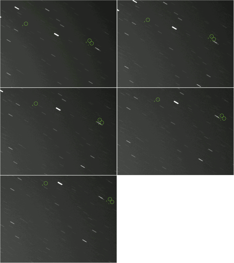
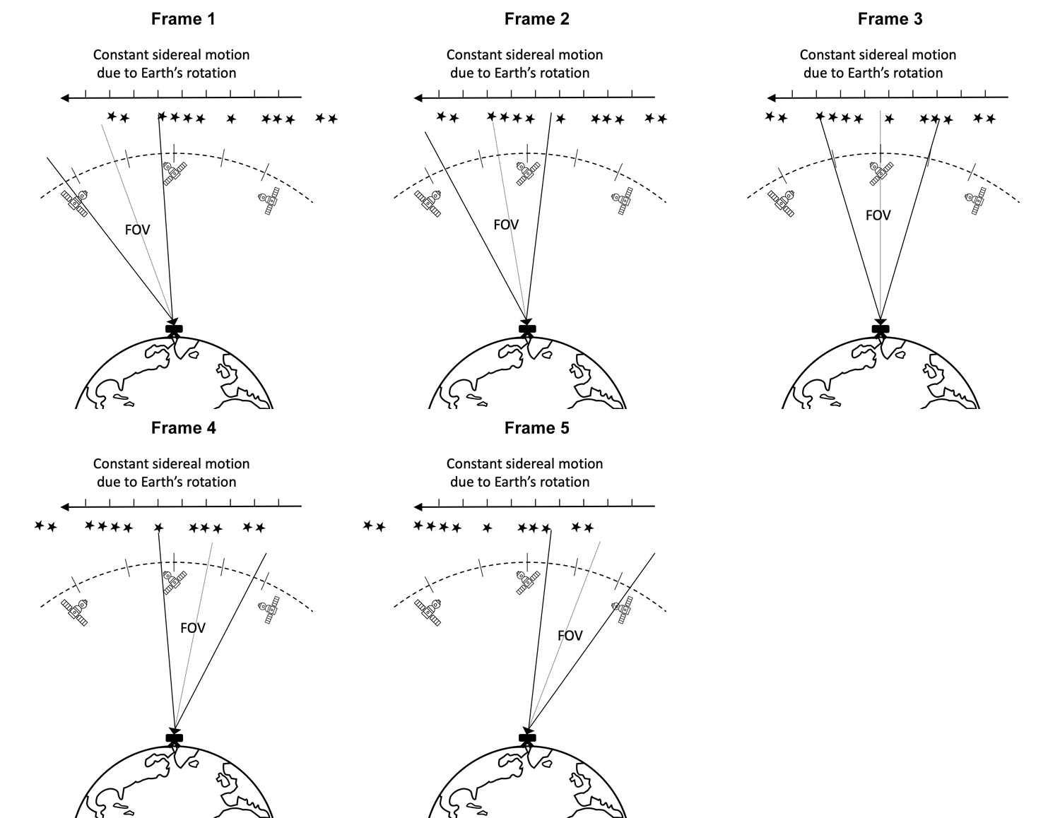
The specific data acquisition approach used for this challenge is illustrated in the diagram above: each capture instance yielded a sequence of 5 images or frames. For each frame, a 40-second exposure was used while the camera was kept static on the ground (equivalently, the camera was rotating at sidereal rate during exposure). After each frame in one instance had been recorded, the camera was slightly rotated to observe a different field of view (FOV) still overlapping with the previous FOV. The figure above illustrates (out of scale) such a process. Eventually this methodology resulted in sequences of five frames such as those shown above, where, as an example, 3 objects are also clearly marked.
Note that under the adopted capture regime, stars appear as streaks, while GEO or near-GEO objects mostly appear as blobs or shorter streaks since they are (mostly) static relative to the observer.
Why is this problem difficult?
A fundamental reason behind the difficulty of this problem is the extreme distance between the observer and the target objects. In the case of the employed telescope, having an angular pixel size of about 4.5 arc seconds and the distance between the ground level and GEO, each pixel corresponds to an arc length of about 800m at GEO. Hence, targets of interest are no larger than 1 pixel in area. With atmospheric distortion and the long exposure time, the received photons from an orbiting object are then smeared over a few pixels; however, this has the effect of dimming the observed object.
Other nuisance factors also contribute to the difficulty of the problem: cloud cover, atmospheric/weather effects, light pollution, sensor noise/defects, star occlusion (when a background star happened to cross the image coordinates of an orbiting object) and in rare cases, orbital manoeuvres conducted by an active GEO satellite during capture.
A number of algorithms [1-7] have been already developed for similar problems, but it is currently unclear what the best approaches are. This competition serves as an invitation to the worlds’ machine learning and computer vision experts to develop advanced and effective methods for this important problem.
At the same time, the spotGEO Challenge also addresses also the lack of publicly available datasets for a computer vision perspective on the satellite detection problem; by assembling and releasing such a dataset, the challenge organisers hope to spur more efforts on automated pipelines for the optical detection of objects and enable objective benchmarking of already existing methods in a cooperative manner.
References:
[1] T. Yanagisawa, H. Kurosaki, and A. Nakajima, “Activities of JAXA’s innovative technology center on space debris observation,” in Advanced Maui Optical and Space Surveillance Technologies Conference, 2009.
[2] R. Šára, M. Matoušek, and V. Franc, “RANSACing optical image sequences for GEO and near-GEO Objects,” in Proceedings of the Advanced Maui Optical and Space Surveillance Technologies Conference, 2013.
[3] H. N. Do, T.-J. Chin, N. Moretti, M. K. Jah, and M. Tetlow, “Robust Foreground Segmentation and Image Registration for Optical Detection of GEO Objects,” Advances in Space Research, 2019.
[4] D. Liu, B. Chen, T.-J. Chin, and M. Rutten, "Topological Sweep for Multi-Target Detection of Geostationary Space Objects." arXiv preprint arXiv:2003.09583, 2020.
[5] Schildknecht, T., Hugentobler, U., & Verdun, A. (1995). Algorithms for ground based optical detection of space debris. Advances in Space Research, 16(11), 47-50.
[6] Kouprianov, Vladimir. "Distinguishing features of CCD astrometry of faint GEO objects." Advances in Space Research 41.7 (2008): 1029-1038.
[7] Seitzer, P., Smith, R., Africano, J., Jorgensen, K., Stansbery, E., & Monet, D. (2004). MODEST observations of space debris at geosynchronous orbit. Advances in Space Research, 34(5), 1139-1142.